Pumped Storage Leak Inspection & Repair
Project Type

Project Description
Clay Lined Water Reservoir
Grout Injection to Seal Large Fissures (Water Power Project – applicable to any industry with water retaining structure)
The clay liner of an 842 acre reservoir supporting a 1872 megawatt pump storage facility developed large trench-like features. Reservoir depth ranged from 40 feet to 110 feet. Before a repair could be designed and implemented it was necessary to determine the extent of the cracking. The size of the reservoir and the depth would make this a difficult task.
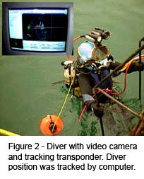
 Engineers working with a diving contractor and marine navigation firm developed a mapping plan that included the use of side scan sonar, short baseline acoustic diver positioning, and differential global positioning (DGPS) of the support vessel. Sonar was used to scan large areas and roughly characterize the cracking. Divers equipped with helmet-mounted video cameras then inspected each feature.
The divers’ position relative to the support vessel was mapped by computer using the acoustic tracking system. The position of the support was plotted by DGPS. By correlating this data, a computer map could be generated to show the precise position of features in the liner.
Divers also entered the features, some of which were ten feet wide and twenty feet deep to provide additional data in support of the sonar findings. Video images and depth readings from the diver pneumo-fathometer helped to ground truth the sonar data.
Engineers were able to use the data to develop a grout mix design and accurately estimate quantities. Survey maps were then used to quickly relocate features during the repair phase.